DEFINITION OF DIFFERENTIAL LEVELING
The establishment of differences in elevation between two or more points with respect to a datum.
Normally we will assign an elevation of 100.00 to the datum rather using the mean sea level elevation.
DEFINITIONS OF KEY TERMS
Set
The location of the level. (where it is set-up)
Bench Mark (BM)
A permanent point of known elevation.
Temporary Bench Mark (TBM)
A point of known elevation.
Turning Point (TP)
An intervening point between BMs or TBMs upon which a backsight and a foresight are taken.
Backsight (BS)
A rod reading taken by "looking back" at a point of known elevation such as a BM or TP.
Foresight (FS)
A rod reading taken when "looking ahead" at a point where you want to determine its elevation, such as a TP, TBM or BM.
Height of Instrument (HI)
The elevation of the line of sight in the telescope of the level.
Balancing of Sights
The rodperson keeps track of the distance of each FS and BS taken and tries to keep them equal.
Closed Circuit
A complete trace of the line of sight of the instrument back to the beginning point.
Closure
The difference between beginning and ending elevations.
THEORY
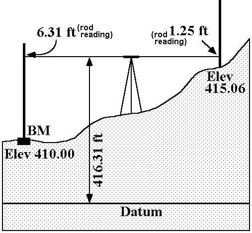
Add rod readings (BS) to benchmark or known turning point elevations to get the elevation of the line of sight (HI).
Subtract rod readings (FS) from the line of sight to establish elevations of unknown points.
Repeat over and over.
SCHEMATIC

Elev + BS = HI
HI - FS = New Elevation
REDUCING ERRORS
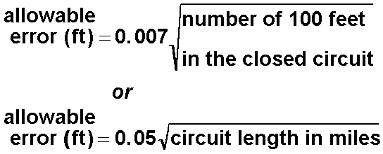
For this class we will use the standard established for Third-order surveying.

find enclosed herewith a detailed presentation on the leveling
The establishment of differences in elevation between two or more points with respect to a datum.
Normally we will assign an elevation of 100.00 to the datum rather using the mean sea level elevation.
DEFINITIONS OF KEY TERMS
Set
The location of the level. (where it is set-up)
Bench Mark (BM)
A permanent point of known elevation.
Temporary Bench Mark (TBM)
A point of known elevation.
Turning Point (TP)
An intervening point between BMs or TBMs upon which a backsight and a foresight are taken.
Backsight (BS)
A rod reading taken by "looking back" at a point of known elevation such as a BM or TP.
Foresight (FS)
A rod reading taken when "looking ahead" at a point where you want to determine its elevation, such as a TP, TBM or BM.
Height of Instrument (HI)
The elevation of the line of sight in the telescope of the level.
Balancing of Sights
The rodperson keeps track of the distance of each FS and BS taken and tries to keep them equal.
Closed Circuit
A complete trace of the line of sight of the instrument back to the beginning point.
Closure
The difference between beginning and ending elevations.
THEORY
Add rod readings (BS) to benchmark or known turning point elevations to get the elevation of the line of sight (HI).
Subtract rod readings (FS) from the line of sight to establish elevations of unknown points.
Repeat over and over.
SCHEMATIC

Elev + BS = HI
HI - FS = New Elevation
REDUCING ERRORS
- Make certain the bubble is centered when you make a rod reading.
- Keep the rod plumb when the reading is taken.
- Establish equal BS and FS reading distances.
- Equal reading distances will cancel out any error caused by the line of sight not being parallel with the axis of the bubble tube on the Dumpy Level.
- Not as important with the self-leveling Automatic Levels.
- Not always possible due to terrain.
- Faulty reading of the rod.
- Not fully extending the rod for high readings.
- Touching the tripod during reading.
- Confusion between recording BS and FS entries into the field book.
- Page Check
Method of checking arithmetic.
The BS and FS columns are added up and their difference should be equal to the difference between the beginning and ending elevations. - Closure Method of checking accuracy.
The difference between the beginning and ending elevations for a loop or the difference between the ending elevation and the known elevation of the ending BM.
For this class we will use the standard established for Third-order surveying.

find enclosed herewith a detailed presentation on the leveling
